3D-моделі та симуляції

3D Geography - helping with the teaching and learning of Geography.
Fun ideas for learning about Geography for kids. Packed with lots of information, geography model ideas, activities and geography worksheets to help you learn.
Original link
OpenFOAM | The OpenFOAM Foundation
Home of OpenFOAM, the CFD software licensed free and open source only, by us — The OpenFOAM Foundation — managed and developed primarily by CFD Direct.
Original link
MODFLOW and Related Programs | U.S. Geological Survey
MODFLOW is the USGS's modular hydrologic model. MODFLOW is considered an international standard for simulating and predicting groundwater conditions and groundwater/surface-water interactions. MODFLOW 6 is presently the core MODFLOW version distributed by the USGS. The previous core version, MODFLOW-2005, is actively maintained and supported as well.
Original link
SWAT | Soil & Water Assessment Tool
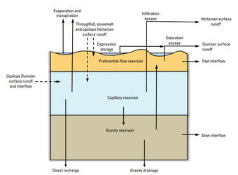
The Soil & Water Assessment Tool is a small watershed to river basin-scale model used to simulate the quality and quantity of surface and ground water and predict the environmental impact of land use, land management practices, and climate change. SWAT is widely used in assessing soil erosion prevention and control, non-point source pollution control and regional management in watersheds.
Original link
Precipitation Runoff Modeling System (PRMS) | U.S. Geological Survey
The Precipitation-Runoff Modeling System is a deterministic, distributed-parameter, physical process based modeling system developed to evaluate the response of various combinations of climate and land use on streamflow and general watershed hydrology.
Original link
iRIC - iRIC Software
iRIC (International River Interface Cooperative) is a river flow and riverbed variation analysis software package which combines the functionality of MD_SWMS, developed by the USGS (U.S. Geological Survey) and RIC-Nays, developed by the Foundation of Hokkaido River Disaster Prevention Research Center.
Original link
SAGA - System for Automated Geoscientific Analyses
SAGA System for Automated Geoscientific Analyses
Original link
Blender Market
A Unique Market for Creators that love Blender
Original link
NGA - Office of Geomatics
Enabling GEOINT accuracy through geodetic, geophysical and photogrammetric sciences and content.
Original link