Geology.com is one of the world's leading portals to geology and Earth science news and information for rocks, minerals, gemstones, energy, volcanoes, earthquakes, careers, geologic hazards, and more.
Worldofmaps.net is a directory for free maps and travel information. You find all kind of maps of the world, sorted by continent and country. Additionally we have a search function, see in the menu on the left side.
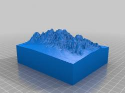
l➤ terrain2stl 3d models ✅. This is a sample print using the Terrain2STL site here: http://jthatch.com/Terrain2STL/Site parameters were NW corner at (38.8898 N, -77.0752 E), box width 0.05 degrees, box height 0.03 degrees, vertical scaling 4. ... Other parameters as......
Enter your email and we'll send you reset instructions
Network
My requests
You don't have any notifications
You have no active requests
Please introduce yourself to proceed
My Uploads
Score:
Embed HTML
Many sites and online services, like Google Maps, suggest HTML code (usually iframes) to embed widgets and content on your page.
You can add such HTML widgets in your quizzes.
Please note:
In case pasted code is not just iframe tag it will be wrapped into HTTPS iframe.
Only HTTPS sources for iframes, styles and javascript links are supported.
Non-HTTPS sources will be blocked by the browser and won't behave properly.