You are seeing the paginated version of the page.
It was specially created to help search engines like Google to build the proper search index.

Click to load the full version of the page
KSA, Kingdom of Saudi Arabia 3D Model - Buy Royalty Free 3D model by LibanCiel
Saudi Arabia,[c] officially the Kingdom of Saudi Arabia (KSA),[d] is a country on the Arabian Peninsula in Western Asia. It has a land area of about 2,150,000 km2 (830,000 sq mi), making it the fifth-largest country in Asia, the second-largest in the Arab world, and the largest in Western Asia. It is bordered by the Red Sea to the west; Jordan, Iraq, and Kuwait to the north; the Persian Gulf, Qatar and the United Arab Emirates to the east; Oman to the southeast; and Yemen to the south. Bahrain is an island country off the east coast. The Gulf of Aqaba in the northwest separates Saudi Arabia from Egypt. Saudi Arabia is the only country with a coastline along both the Red Sea and the Persian Gulf, and most of its terrain consists of arid desert, lowland, steppe, and mountains. Its capital and largest city is Riyadh. The country is home to Mecca and Medina, the two holiest cities in Islam. Source: Wikipedia.org - KSA, Kingdom of Saudi Arabia 3D Model - Buy Royalty Free 3D model by LibanCiel
Original link
China 3D Model - Buy Royalty Free 3D model by LibanCiel
China (Chinese: 中国; pinyin: Zhōngguó), officially the People’s Republic of China (PRC; Chinese: 中华人民共和国; pinyin: Zhōnghuá Rénmín Gònghéguó), is a country in East Asia. It is the world’s most populous country, with a population of more than 1.4 billion people. China spans five geographical time zones and borders 14 countries, the second most of any country in the world after Russia. Covering an area of approximately 9.6 million square kilometers (3,700,000 sq mi), it is the world’s third or fourth largest country.[i] The country consists of 23 provinces,[j] five autonomous regions, four municipalities, and two Special Administrative Regions (Hong Kong and Macau). The national capital is Beijing, and the most populous city and financial center is Shanghai. Modern Chinese trace their origins to a cradle of civilization in the fertile basin of the Yellow River in the North China Plain. Source: Wikipedia.org - China 3D Model - Buy Royalty Free 3D model by LibanCiel
Original link
Philippine 3D Map Low Poly - Buy Royalty Free 3D model by AnshiNoWara
UPDATED March 4, 2022 | 1:28 PM | Pacific Time Remade Island textures and water textures. Fixed the 3D model’s flipped faces on one of the small islands in the north Reuploaded the MTL and OBJ files with TEXTURES folder Added an FBX file with embedded textures New textures and files may take some time to reupload A low poly 3D map of the Philippine Islands. This is not an exact or accurate representation of the whole country since the Philippines contains an estimate of 7,100 (Seven Thousand, One Hundred) islands. - Philippine 3D Map Low Poly - Buy Royalty Free 3D model by AnshiNoWara
Original link
Washington State - Buy Royalty Free 3D model by JohnHoagland
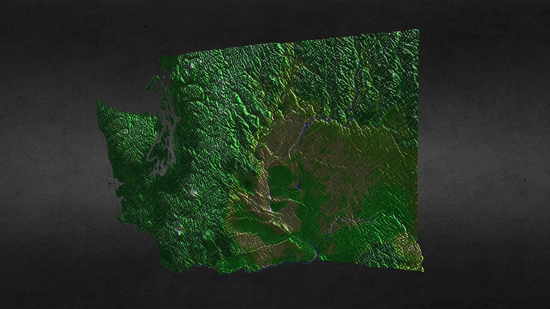
Washington, officially the State of Washington, is a state in the Pacific Northwest region of the United States. Named after George Washington, the first president of the United States, the state was made out of the western part of the Washington Territory, which was ceded by Britain in 1846 in accordance with the Oregon Treaty in the settlement of the Oregon boundary dispute. Washington is the 18th largest state, with an area of 71,362 square miles, and the 13th most populous state, with over 7.4 million people. This is a digital model of the state of Washington in the United States. Approx 27620 polygons. Made with 3 point polygons (triangles). The topology is modelled into the mesh. Does not include any separate parts. This version includes an mtl file, which your software program should read to colorize the model. The model has basic UV mapping and a texture and bump at 937x611 pixels are included. Original model by Digimation and sold here with permission. - Washington State - Buy Royalty Free 3D model by JohnHoagland
Original link
EarthGlobe - Buy Royalty Free 3D model by gpz3d
Video preview: https://youtu.be/GDwmu-Ig62w [Zip File] No textures Mesh Information: Polygon Mesh: Shade smooth, sharp edge Poly count: 47981 faces, 86212 tris Subdivision: Not recommended UV unwrapped: Overlapping Formats include: .obj .fbx .blend ~ If you have questions or problems, please feel free to contact me. - EarthGlobe - Buy Royalty Free 3D model by gpz3d
Original link
California State - Buy Royalty Free 3D model by JohnHoagland
California is a state in the Pacific Region of the United States of America. With 39.5 million residents, California is the most populous state in the United States and the third most extensive by area. The state capital is Sacramento. The Greater Los Angeles Area and the San Francisco Bay Area are the nation’s second- and fifth-most populous urban regions, with 18.7 million and 8.8 million residents respectively. Los Angeles is California’s most populous city, and the country’s second-most populous, after New York City. This is a digital model of the state of California in the United States. Approx 41353 polygons. Made with 3 point polygons (triangles). The topology is modelled into the mesh. Does not include any separate parts. This version includes an mtl file, which your software program should read to colorize the model. The model has basic UV mapping and texture and bump maps, at 1233x1429 pixels, are included. Original model by Digimation and sold here with permission. - California State - Buy Royalty Free 3D model by JohnHoagland
Original link
Korean Peninsula - Buy Royalty Free 3D model by JohnHoagland
Korea is a region in East Asia; since 1945, it has been divided into two distinct sovereign states: North Korea and South Korea. Korea emerged as a singular political entity in 676 AD, after centuries of conflict among the Three Kingdoms of Korea, which were unified as Unified Silla to the south and Balhae to the north. Unified Silla divided into three separate states during the Later Three Kingdoms period. Goryeo, which had succeeded Goguryeo, defeated the two other states and united the Korean Peninsula. This is a digital model of the Korean peninsula with color-separated regions for North Korea and South Korea. Approx 6224 polygons. Made with 3 and 4 point polygons. Includes different colors to separate the regions. Includes separate parts for each region. This version includes an mtl file, which your software program should read to colorize the model. The model has basic UV mapping and NO textures are included. Original model by Digimation and sold here with permission. - Korean Peninsula - Buy Royalty Free 3D model by JohnHoagland
Original link
Australia 3D Model - Buy Royalty Free 3D model by LibanCiel
Australia is a sovereign country comprising the mainland of the Australian continent, the island of Tasmania, and numerous smaller islands. With an area of 7,617,930 sq kilometres (2,941,300 sq mi), Australia is the largest country by area in Oceania and the world’s sixth-largest country. Australia is the oldest, flattest, and driest inhabited continent, with the least fertile soils. It is a megadiverse country, and its size gives it a wide variety of landscapes and climates, with deserts in the centre, tropical rainforests in the north-east, and mountain ranges in the south-east. Indigenous Australians have inhabited the continent for approximately 65,000 years. The European maritime exploration of Australia commenced in the early 17th century with the arrival of Dutch explorers. In 1770, Australia’s eastern half was claimed by Great Britain and initially settled through penal transportation to the colony of New South Wales from 26 January 1788, a date which became Australia’s national day. Wikipedia.org - Australia 3D Model - Buy Royalty Free 3D model by LibanCiel
Original link
USA, United States of America 3D Relief Model - Buy Royalty Free 3D model by LibanCiel
The United States of America (U.S.A. or USA), commonly known as the United States (U.S. or US) or America, is a transcontinental country primarily located in North America. It consists of 50 states, a federal district, five major unincorporated territories, nine minor outlying islands,[i] and 326 Indian reservations with limited sovereignty. It is the third-largest country by both land and total area.[c] The United States shares land borders with Canada to the north and with Mexico to the south as well as maritime borders with the Bahamas, Cuba, and Russia, among others.[j] It has a population of over 331 million,[d] and is the third most populous country in the world. The national capital is Washington, D.C., and the most populous city and financial center is New York City. The United States is a melting pot of cultures and ethnicities, and its population has been profoundly shaped by centuries of immigration. It has a highly diverse climate and geography. Source: Wikipedia.org - USA, United States of America 3D Relief Model - Buy Royalty Free 3D model by LibanCiel
Original link